Overview of satellite imaging
What is Satellite Imagery?
- Satellite imagery refers to pictures of Earth or other planets taken from satellites in space.
- These images are used for various purposes like mapping, environmental monitoring, and disaster management.
Types of Satellite Images
- Multispectral: Captures data at different wavelengths across the electromagnetic spectrum. Useful for observing vegetation, water bodies, and urban areas.
- Hyperspectral: Captures hundreds of narrow spectral bands. Provides detailed information about the materials present in the scene.
- Radar (Synthetic Aperture Radar - SAR): Uses radio waves to capture images. Can penetrate clouds and is useful for all-weather imaging.
Sentinel Satellites
- Sentinel-1: Provides radar imagery for land and ocean monitoring.
- Sentinel-2: Captures multispectral images with high spatial resolution. Useful for land monitoring, agriculture, and forestry.
- Sentinel-3: Focuses on ocean and land monitoring, providing data for climate monitoring and weather forecasting.
Applications of Satellite Imagery
- Environmental Monitoring: Tracking changes in forests, water bodies, and glaciers.
- Urban Planning: Mapping urban areas and monitoring infrastructure development.
- Disaster Management: Assessing the impact of natural disasters like floods, earthquakes, and hurricanes.
- Agriculture: Monitoring crop health, estimating yields, and managing resources.
Key Concepts
- Resolution: The level of detail in the image. Includes spatial (size of the smallest object), spectral (number of wavelength bands), temporal (frequency of image capture), and radiometric (sensitivity of the sensor).
- Georeferencing: Aligning satellite images with geographic coordinates so they can be used with maps and other spatial data.
- Data Preprocessing: Steps to prepare satellite images for analysis, such as correcting atmospheric effects, removing noise, and aligning images from different dates.
Tools and Software
- QGIS: Open-source geographic information system for viewing and analyzing spatial data.
- SNAP (Sentinel Application Platform): Software specifically designed for processing Sentinel satellite data.
Research in Details

Satellite imagery refers to the process of capturing visual data of the Earth's surface from satellites orbiting our planet. These satellites are equipped with specialized cameras and sensors that collect high-resolution images of the Earth's surface, which are then transmitted back to Earth for analysis. The images can range from panchromatic to multi-spectral, capturing a wide spectrum of data, including visible light, infrared light, and microwave radiation.
Key Points about Satellite Imagery:
- Types of Imagery: Satellite images can be categorized into different types based on the spectrum of light they capture, such as visible light, infrared light, and water vapor imagery.
- Applications: Satellite imagery has numerous applications across various fields, including weather forecasting, oceanography, agriculture, biodiversity conservation, forestry, and urban planning.
- Data Characteristics: The resolution of satellite images varies depending on the instrument used and the altitude of the satellite's orbit. The Landsat archive, for example, offers repeated imagery at 30-meter resolution for the planet.
- Processing: The raw data from satellites is processed to produce useful imagery and datasets. This includes procedures such as calibration, atmospheric interference correction, and georeferencing to provide geographic locations to the images.
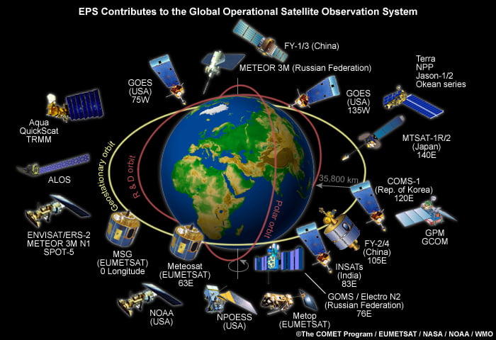
- Orbits: Satellites can be deployed in various orbits, such as polar orbits and geostationary orbits, depending on their purpose. Polar orbits allow for global coverage, while geostationary orbits remain stable over a certain location on the Earth's surface.
Satellite imagery is a crucial technology for understanding and managing our planet, providing a wealth of information that cannot be obtained from cameras on the ground level.
How do satellites capture images of the Earth?
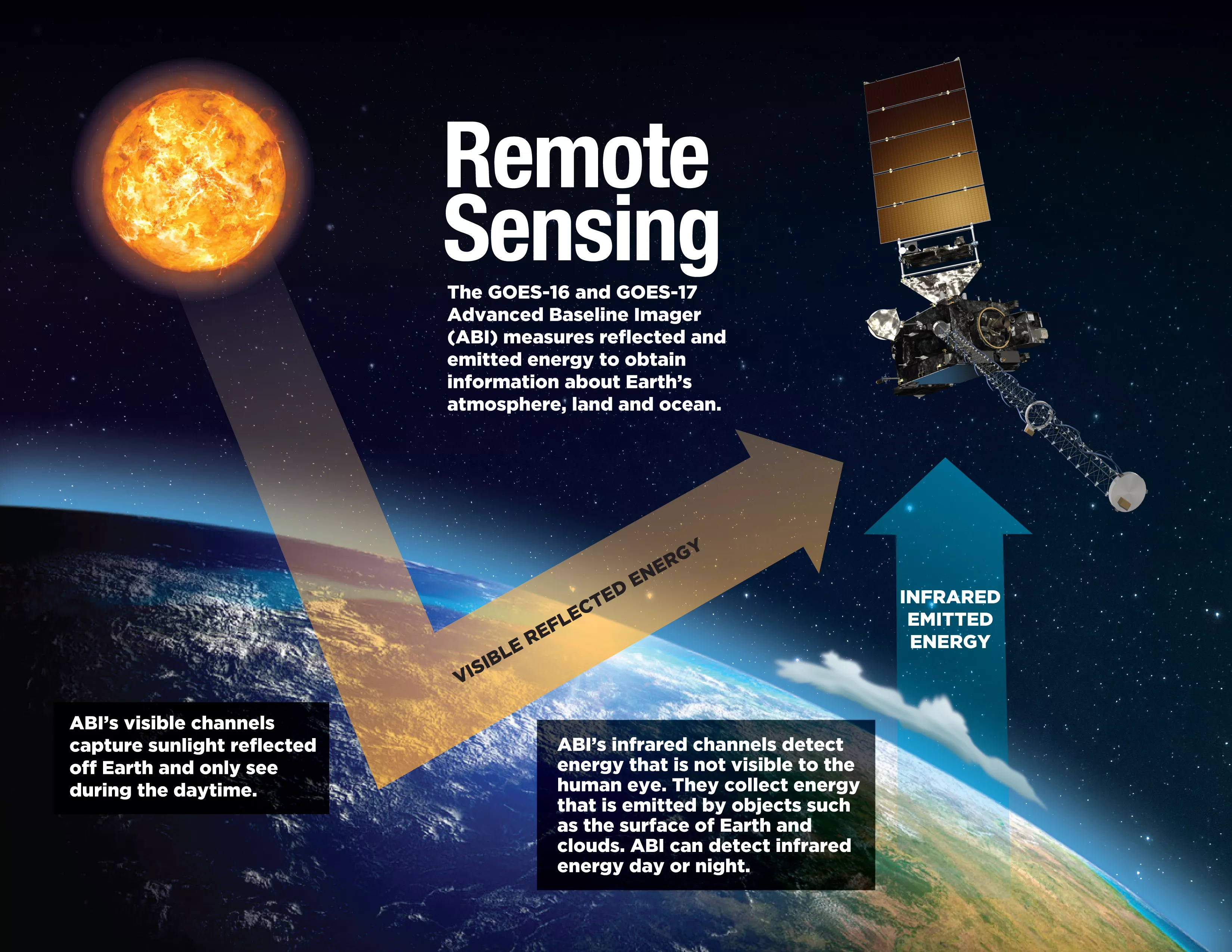
Satellites capture images of the Earth using various types of sensors that collect electromagnetic radiation reflected from the Earth's surface. There are two main types of sensors:
-
Passive sensors collect radiation emitted by the Sun and reflected off the Earth. They do not require their own energy source.
-
Active sensors emit their own radiation and analyze the reflection. While they require more energy, active sensors can be used day or night and in any season, unlike passive sensors which cannot operate in shadows.
Satellite sensors can detect different parts of the electromagnetic spectrum beyond just visible light, such as infrared, ultraviolet, and microwaves. These invisible wavelengths are then assigned visible colors to create the final satellite images.
The way objects reflect radiation helps identify different surfaces. Smooth surfaces like roads reflect energy in a single direction (specular reflection), while rough surfaces like trees reflect in all directions (diffuse reflection). This allows measuring forest density and changes over time.
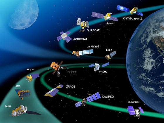
The Landsat series of satellites, first launched by NASA in 1972, has provided 40+ years of Earth observation data used for monitoring climate, forests, water, and more. Other major satellite imaging programs include those from the European Space Agency, private companies, and government agencies around the world.
While satellite imagery has many applications, there are some limitations. The sheer volume of data is massive, and preprocessing is often required to create usable images from raw sensor data. Weather conditions like clouds can also impact image quality in some areas.
What are the different types of satellite imagery?
The main types of satellite imagery are:
-
Optical Satellite Imagery:
- Multispectral Imagery: Captures data in multiple wavelength bands beyond the visible spectrum, used for environmental monitoring, vegetation analysis, and land cover classification.
- Hyperspectral Imagery: Collects a large number of narrow, contiguous spectral bands, enabling in-depth analysis for applications like pollution detection, precision farming, and mineral identification.
- Panchromatic Imagery: Captures a wide spectrum of visible light in a single high-resolution band, useful for infrastructure, urban planning, and visual interpretation.
-
Radar Satellite Imagery:
- Synthetic Aperture Radar (SAR): An active remote sensing technique that produces high-resolution images by measuring microwave reflections, used for topography mapping, subsidence monitoring, and disaster response.
- Interferometric SAR (InSAR): Merges multiple SAR images to produce interferograms and track surface deformations over time, essential for monitoring tectonic activity, landslides, and ground subsidence.
-
Thermal Infrared Imagery: Captures the heat emitted by surfaces, providing insights into temperature variations for applications like natural ecosystem research, urban heat island monitoring, and energy efficiency evaluation.
-
LiDAR Satellite Imagery: Uses laser beams to create precise 3D models of the Earth's surface, crucial for forest management, terrain modeling, and urban planning.
These different types of satellite imagery leverage various parts of the electromagnetic spectrum to capture a wide range of information about the Earth's surface and atmosphere, enabling diverse applications in fields like environmental monitoring, urban planning, and disaster response.